Page 41 - My FlipBook
P. 41
HAN mini UAV
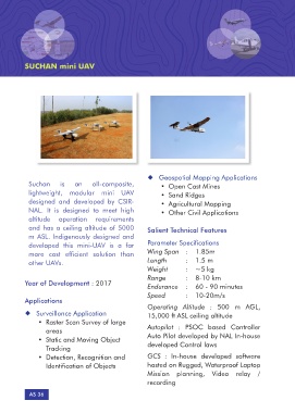
Suchan is an all-composite, ¡¡ Geospatial Mapping Applications
lightweight, modular mini UAV • Open Cast Mines
designed and developed by CSIR- • Sand Ridges
NAL. It is designed to meet high • Agricultural Mapping
altitude operation requirements • Other Civil Applications
and has a ceiling altitude of 5000
m ASL. Indigenously designed and Salient Technical Features
developed this mini-UAV is a far
more cost efficient solution than Parameter Specifications
other UAVs. Wing Span : 1.85m
Length : 1.5 m
Year of Development : 2017 Weight : ~5 kg
Range : 8-10 km
Applications Endurance : 60 - 90 minutes
Speed : 10-20m/s
¡¡ Surveillance Application
• Raster Scan Survey of large Operating Altitude : 500 m AGL,
areas 15,000 ft ASL ceiling altitude
• Static and Moving Object
Tracking Autopilot : PSOC based Controller
• Detection, Recognition and Auto Pilot developed by NAL In-house
Identification of Objects developed Control laws
AS 36 GCS : In-house developed software
hosted on Rugged, Waterproof Laptop
Mission planning, Video relay /
recording